GCS uses a 3D surface to plot points on a projection. Latitude and longitude is used to locate a point as they represent angles from the center of the earth. The mercator form of projection is a plane coordinate system as it splits the earth into zones which preserves direction. It distorts the size of geographic objects and does not show both poles.
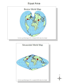
The bonne projection, which appears to have a similar shape to a heart, preserves the area of the map. There is no distortion along the central meridian and all of the parallels have the same scale as the central meridian in concentric circles. It is a pseudo conic projection with extremely distorted shape. The sinusoidal projection also preserves the area via a pseudo conic projection. There is no distortion on the central meridian or the equator, however the shape can be distorted especially near the poles. The features in this projection are more concentrated together than in the GCS map, for example.
The equidistant conic world map, as indicated by its name, preserves distance and is crated by conic projection. It has the same scale along all the meridians with a pacman shape to it. Both area and shape are extremely distorted, it appears as though antarctica is slowly eating up the world while the other landmasses are clumped together. The plate caree world map is a plane projection map with no distortion along the equator. It preserves distance, however these two maps exhibit differing distances between DC and Kabul because they are not on the same meridian. As they are slightly skewed, the distances are not equal. The map appears to be more elongated, as the continents are oddly wide and short.


Good. Just a point of semantics: GCS is specifically NOT a projection. No worries, I think you understood it.
ReplyDelete10/10